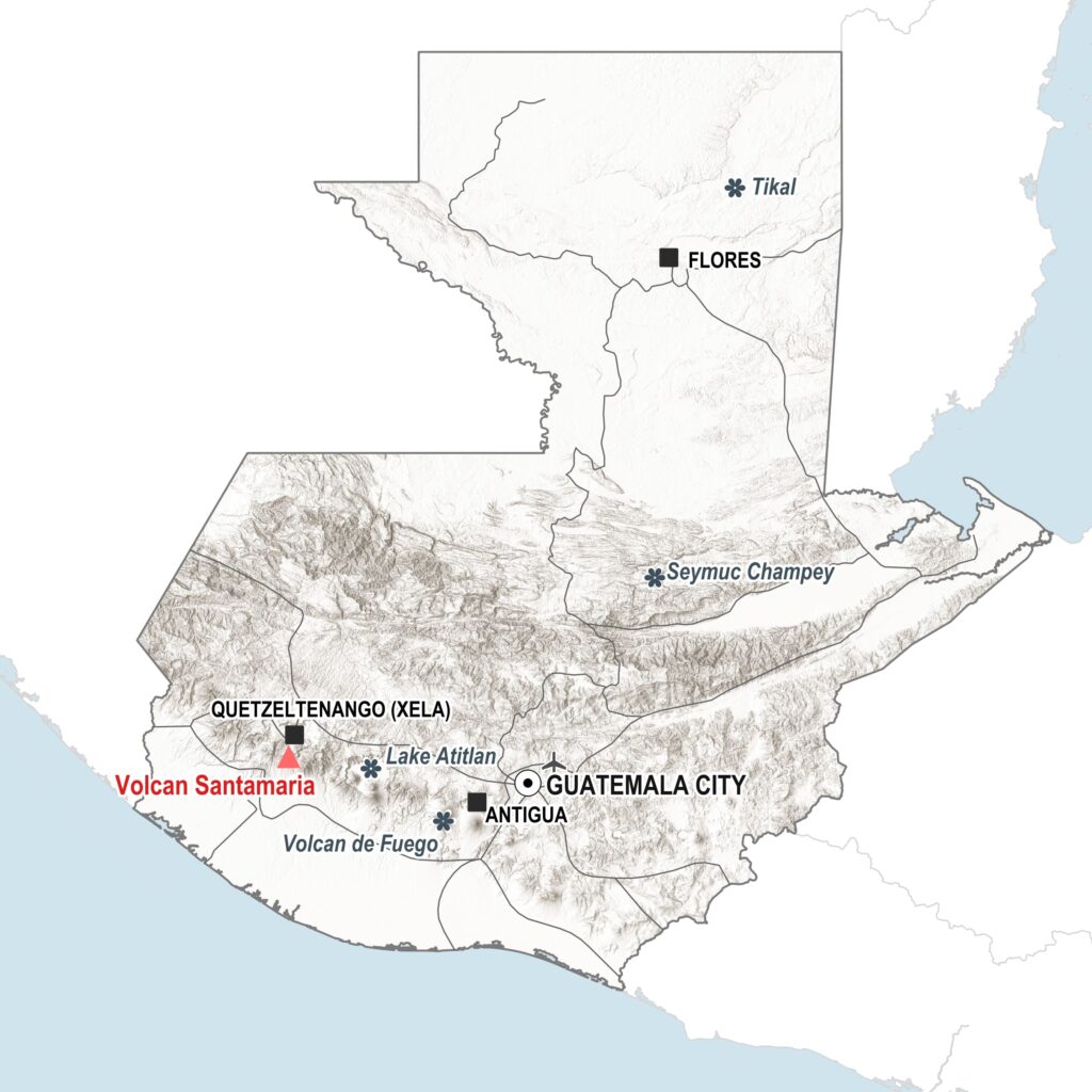
Guatemala 14.73, -91.56. Hike to the top of Santa Maria volcano or the nearby viewpoint for stunning views of Santiaguito’s eruptions. Located just outside Quetzaltenango, this Guatemalan volcano is currently the world’s longest confirmed continually erupting volcano. Read on for travel tips and some volcanic facts!
Published July 25th 2025 by Josef Clifford.
The small country of Guatemala is packed with 37 volcanoes. Two of these, Fuego and Santiaguito, are currently very active (as of July 2025). One more, Pacaya, has been active in the past five years. A further 4 have erupted in the past 200 years.
Santiaguito is a lava dome1 that’s been growing and almost continuously erupting since 1922. It sits behind the symmetrical forested Santa Maria volcano, which last erupted in 1902. It was one of the largest eruptions of the 20th Century, forming a 1.5km crater that stretches from the summit to the lower flank, with Santiaguito forming at the lower end.
You can see Santiaguito’s eruptions from the summit of Santa Maria or by taking the less arduous trail to the viewpoint (mirador). Because of the location of Santiaguito behind Santa Maria you won’t see it until you reach the summit or the viewpoint. However, once there, you shouldn’t have to wait long to see one of the spectacular twice-hourly eruptions.2
Getting there: The nearest city is Quetzaltenango (Xela). Check Busbud for major bus routes, or see the practicalities section below for more travel info.
Where to stay: there are plenty of places to stay in Xela. I stayed in this AirBnB which was in a great location with beautiful views over the cathedral, although on quite a noisy street. Tripadvisor has a number of hotel options, including reviews.
Safety: volcanoes can be very dangerous – it’s important to check for recent volcanic activity alerts. Do not proceed past the viewpoint or hike to Santiaguito itself – this is risking your life. You’ll find the latest weekly bulletins here, but check the news as well.
Jump to a section
> Arrival in Xela
> The climb to the viewpoint (or the summit)
> Volcanology section
> Practicalities & more to see in Guatemala
Done Fuego? Looking for another volcano experience in Guatemala?
I visited Santiaguito as part of a long trip around Central America. I’d already been to Fuego and seen eruptions and lava flows there (which are spectacular – a tough hike but not to be missed. I’d recommend this tour with CA Travelers – book on TripAdvisor here). Now I was looking for one final volcano experience. I realised there were a few options close to Guatemala’s second city, Quetzaltenango.
Quetzaltenango is actually the Spanish-adopted name for the city. It’s more commonly known by the local name, Xela (pronounced shella). About 95% of the population is indigenous Maya or mixed race and the city is known as being the largest urban centre with a Mayan majority.
Sitting at an elevation of 2,330 m (7640 ft), the climate is noticeably cooler up here. I was staying in an AirBnB opposite the main cathedral in Xela. It’s in a great location with beautiful views over the city and mountains beyond. However, if you’re a light sleeper like me, good luck with the traffic noise. It doesn’t seem to let up much through the night! You can also check on Tripadvisor for accommodation options.
An early start
The next morning, I forced myself out of bed at 5am. Despite the thick cloud out my window, I decided to go ahead with my original plan to visit the volcano. It was my only opportunity as I already had a shuttle booked to Mexico for the next morning.
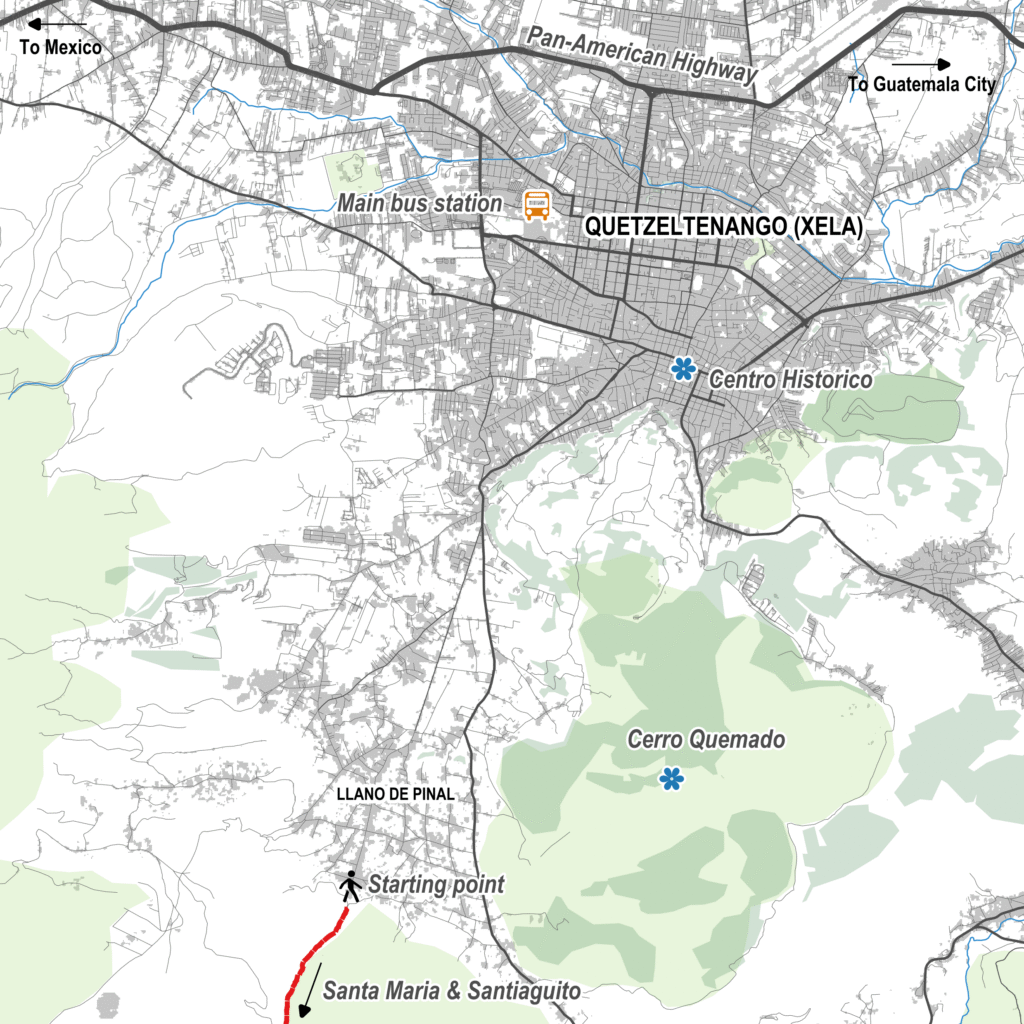
So I found myself in an Uber by 5:24am. Destination: Hospedaje Santamaría, the starting point for the hike. The journey took just 15 minutes and set me back GTQ30 (around $4USD). Heading directly into thick cloud through the dusty streets of Llano de Pinal, the prospects of seeing much were looking slim I have to say.
On my way up, I passed a few farmers and soon found myself being followed by a little group of stray dogs. I’m always a bit wary of stray dogs, especially after a slightly traumatic experience last year where I was chased and surrounded by a pack in a park in Tunisia. These ones seemed quite friendly though!
To the summit or the viewpoint
The trail is marked with red and blue arrows. After about 1.5km of steep-ish ascent, the trail splits in two. The red arrows head to Santa Maria summit and the blue arrows to the Santiaguito viewpoint.
Make sure you follow the correct arrows! I would highly recommend downloading the All Trails app and downloading the route. You need the Plus version to do this, but you might be able to get a free trial. This way the route’s available to you offline when hiking. It’s easy to take a wrong turn otherwise!
> Find the routes here: Santa Maria volcano summit and Santiaguito viewpoint.
My original plan had actually been to head to the summit. However, the morning fog had lifted a bit and I realised I should have a clear window to see the volcano from this elevation. So, I decided to head to the viewpoint. I also knew it would get cloudy by mid to late morning this time of year, so if I’d headed to the summit, it was very likely to be clouded over.
This turned out to be a good call. The one other hiker I had seen ahead of me at the start of the hike, who I actually bumped into on the bus the following day, said she’d headed up to the summit and didn’t manage to see anything!
Note on altitude sickness: the maximum altitude on the viewpoint hike is around 2,860m, whilst the summit is around 3,770m. To avoid altitude sickness, it’s best to acclimatise in Xela for a couple of days before attempting the hikes. Take it slow and drink plenty of water!
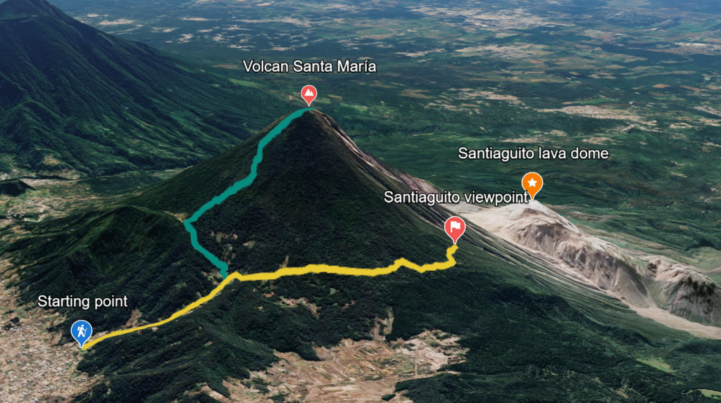
After the trail forked, I passed no one else. The trail flattens out as it heads around the side of the volcano. You’ll pass through some private land and will have to climb over a couple of fences to continue on the path. If you meet the landowner, you may be asked to pay a small fee for the privilege, which I’d say is fair enough.
Arrival at the viewpoint
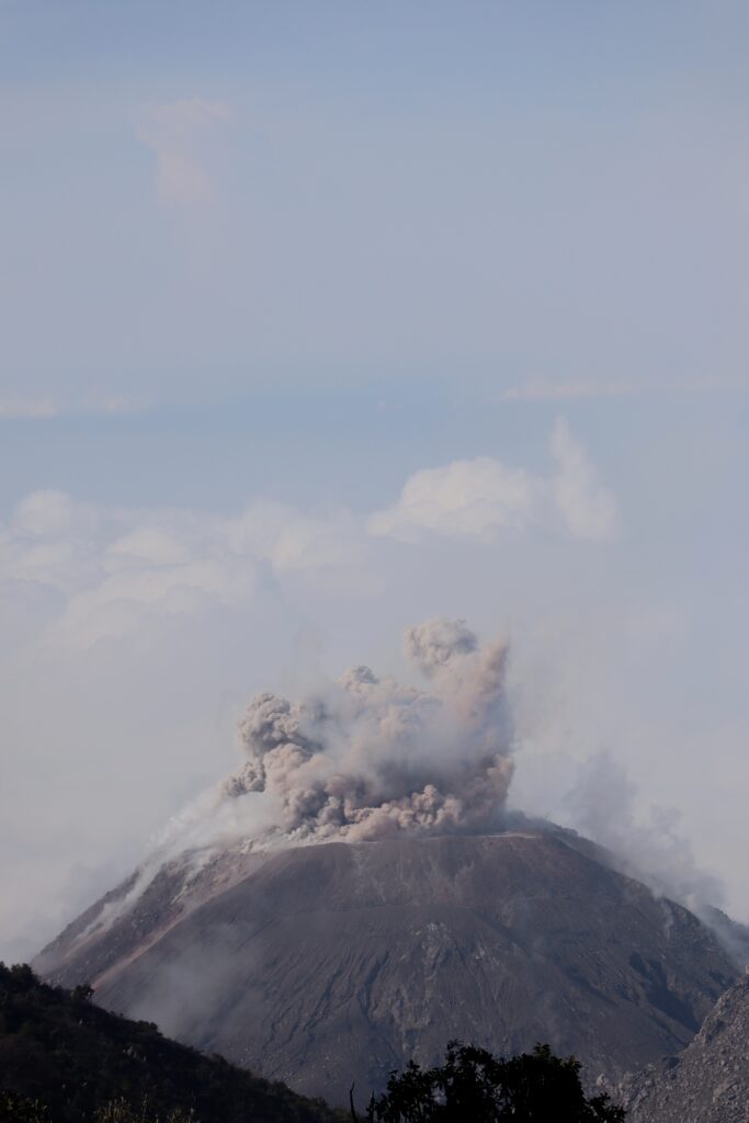
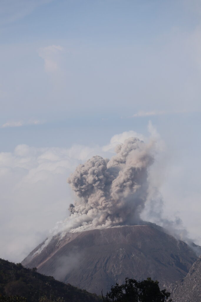
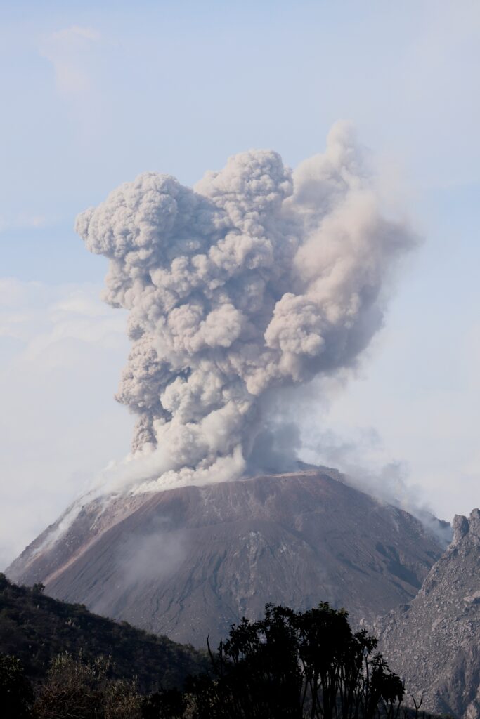
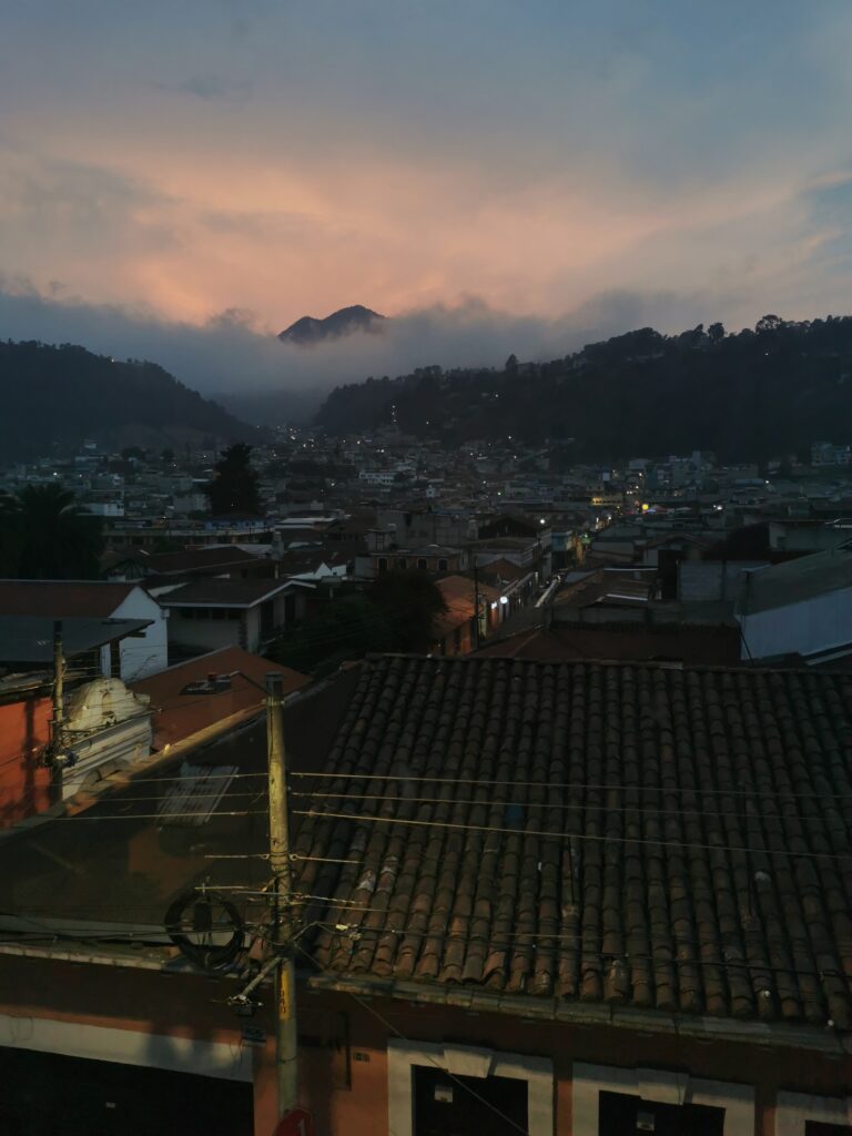
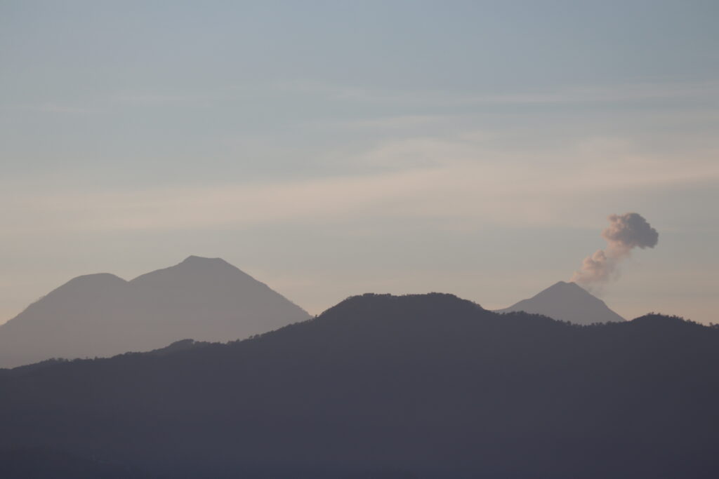
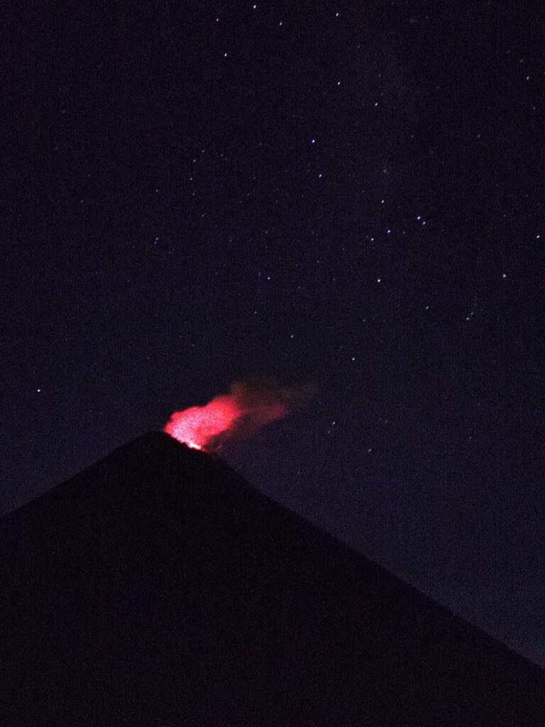
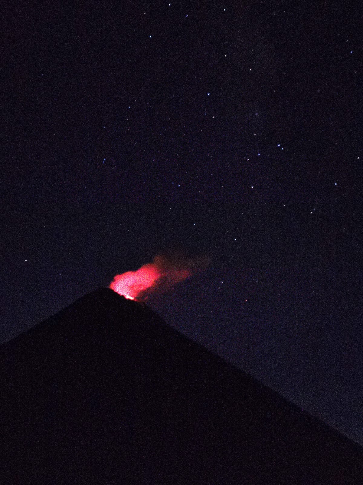
Eventually, you’ll come around the other side of the volcano and reach a small inconspicuous clearing. Here, Santiaguito and the lightly steaming fresh lava suddenly appears in front of you.
Within just a few minutes of my arrival, the volcano suddenly erupted. Huge billowing clouds of ash and smoke shot into the atmosphere. The deep rumbling explosions were a bit shocking the first time.

I stayed here for about an hour and a half and saw two eruptions. The second one was even bigger. Activity does vary and I was lucky enough to visit at a time of heightened activity (just the right amount to observe safely from this location). In the past it was actually possible to hike to the summit of Santiaguito itself, but this would be a death wish now.
I slowly made my way back, passing just a couple of local hikers making the ascent towards Santa Maria. At the bottom, I took a taxi back into Xela, had a big delicious sandwich at Rustic Bakery and rested at my AirBnB ready for another early start tomorrow to head back into Mexico.
What’s going on here anyway? – A bit of volcanology
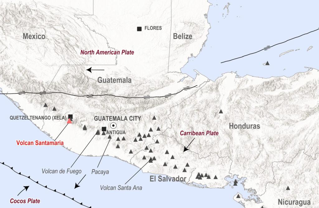
Sitting on the Pacific Ring of Fire, a ring of volcanoes and frequent earthquakes surrounding the Pacific ocean, Santiaguito is a lava dome that forms part of the Santa Maria volcano complex. This complex is itself part of the Central American Volcanic Arc, a chain of volcanoes extending all the way from Guatemala to northern Panama.
The oceanic Cocos Plate converges with the continental Caribbean plate and subducts beneath it due to the higher density of oceanic crust. As the plate subducts, it heats up and melts. This molten rock, or magma, eventually reaches the surface to form volcanoes like Santa Maria.
The last eruption of Santa Maria volcano, estimated 6 on the Volcano Explosivity Index (VEI)3, occurred in 1902. It was one of the largest eruptions of the 20th century. The massive Plinian eruption was similar in scale to the 1991 eruption of Pinatubo in the Philippines and devastated much of southwest Guatemala.
Around 5,000 people were killed by the direct effects of the eruption. It was also preceded by major earthquakes that caused extensive damage in Xela. Thousands more died due to a malaria outbreak following the eruption. Theories suggest this occurred because the heavy ashfall killed birds allowing mosquitoes to flourish.4
The 1902 eruption left a 1.5km wide crater which is clearly visible on the southwest side of Santa Maria. Santiaguito sits at the bottom of this crater. It’s actually a group of lava domes that started erupting from 1922 and have been almost continuously active since. The currently erupting dome is aptly named Caliente (meaning “hot”). In fact, Santiaguito remains the longest confirmed continuously erupting volcano in the world. Perhaps only Yasur volcano in Vanuatu has been erupting for longer.5
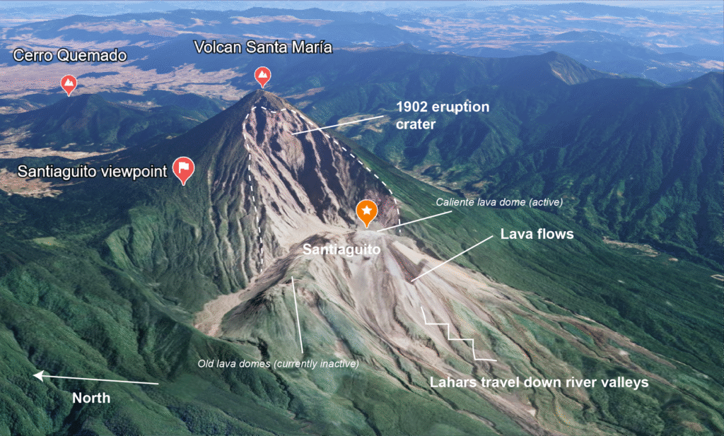
Ash and other volcanic material deposited on Santiaguito’s slopes mix with rainfall during the rainy season resulting in lahars. These deadly mudflows carry large rocks downstream, damaging roads and flattening villages in minutes. The town of El Palmar Viejo was abandoned in 1998 after being destroyed twice by lahars.
Pyroclastic flows, deadly currents of hot gases, ash and lava are another serious hazard here. They flow downslope under gravity and were the same phenomena that destroyed Pompeii in AD79 as people were suffocated by the exceptionally hot gases. Another good reason not to get too close to erupting volcanoes!
Practicalities
Getting there : the closest city to Santiaguito and Santa Maria is Quetzaltenango (Xela). It’s a 7km Uber ride ($4 USD) from the Centro Historico to the starting point of the hike. Alternatively, take a public bus towards Llanos del Pinal, which depart from Parque El Calvario (map link) from around 6am (3Q/$0.40). Pick up a return bus here.
I’d recommend taking an Uber on the way at least. That way you can reach the starting point as early as possible and maximise your chances of a clear view.
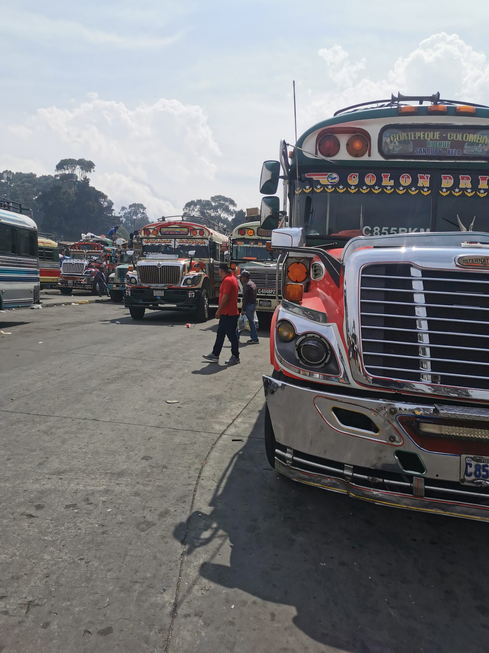
Getting to Xela: there are shuttle buses from major tourist hotspots in Guatemala, as well as Chiapas in Mexico. If you prefer to travel the local way and have some basic Spanish, the local buses will save you a lot of money and provide a more colourful experience.

From San Pedro (Lake Atitlan): shuttles are available – e.g. with Adrenalina Tours ($30, 2.5 hours). Otherwise, you can take a local bus – check with your accommodation for latest times. If you’re coming from Santa Cruz, take a local boat to San Pedro and catch a shuttle from there. Or if you’re feeling adventurous take a local boat to Panajachel, hop on a local bus to Sololá (Maps.Me location), take another from the square (location) to Los Encuentros (location) and finally jump on a bus heading to Xela (this is what I did and was simpler than it sounds).
From Antigua, take a shuttle ($30) or public bus. Transportes Marquensita operates a big bus between Guatemala City and Xela multiple times a day, you can find schedules here (~2 hours). Otherwise take a shuttle or local bus.
There’s also a shuttle available from Xela to San Cristobal de las Casas in Chiapas, Mexico (I took this one). At $60, it’s not cheap but very convenient and avoids the stress and complications of interchanges and navigating border crossings. In reality you get picked up in a small car which takes you to the Pan-American Highway, where you meet a shuttle coming from the east, but it was very smooth and we literally only waited 2 minutes at the junction.
The nearest airport is Guatemala City, located around 210km away. You’ll find flights to a range of destinations across Central and North America, as well as Bogota and Madrid. If you are doing a longer trip around the whole region, you will probably find cheaper flights to Cancun or Mexico City, from where you can travel overland.
Tours: at the time of writing (July 2025), no tours are currently available to the viewpoint due to government restrictions. However, tours are available to Volcan Santa Maria – for example with Quetzaltrekkers. However, in my opinion it’s not really necessary to have a guide and it’s easy to follow the trail if you’ve downloaded the route. At the same time, there have been some reports of muggings and if you don’t feel comfortable travelling on your own, you should go with a guide.
Visas: many nationalities don’t require a visa to enter Guatemala for up to 90 days. You’ll find a list of countries by visa category here.
When to go: Guatemala’s climate includes a wet and dry season, with tourist numbers and prices peaking across two high seasons. November to March are dry and coincide with the first high season. The almost guaranteed clear skies make it perfect for trekking volcanoes. Nighttime temperatures in Xela can reach near freezing at this time of year so make sure to bring warm clothes. June to August mark the second high season. Whilst it can be hot and damp, rain usually falls in the late afternoon and you may be lucky in the mornings.
At other times of year (April-May and September-October), you’ll find less crowds and lower prices. Weather can be unpredictable though and it can get slippery on trails on the volcanoes. However, I went at the start of the rainy season in mid-May and whilst it was cloudy first thing and by mid-morning, I was still able to enjoy a couple of hours of uninterrupted views of Santiaguito. Just keep an eye on the weather and if you can be flexible, you shouldn’t have too many problems.
If you hike during the week, you’re much more likely to avoid the crowds as many hikers flock to the trails on the weekend. See more on when to go and festivals here.
More to see in Guatemala
Fuego and Acetenango volcanoes: this is the classic Central America volcano trek and not to be missed. Starting from the beautiful historic capital, Antigua, it’s a strenuous 1-night trip, but the views of the eruptions and glowing lava flows are incredible. You stay in a basic camp at around 3600m. I went with CA Travelers and would highly recommend them.
Other volcanoes near Xela: beyond Santa Maria, there are a number of dormant and inactive volcanoes around Xela which can be climbed in 1 or 2 days. For example, you can visit Zunil Volcano on a 2 day hike, or Tajumulco – another dormant volcano which is also the highest peak in Central America. There’s also Chicabal and Cerro Quemado, inactive volcanoes with sacred significance for many Guatemalans. Check out this blog for more info.
Lake Atitlan: a spectacular caldera lake surrounded by three volcanoes – Volcan San Pedro is generally considered the most accessible climb. You can also visit the popular Indian Nose viewpoint or hike along the lakeside trail between Santa Cruz and San Marcos. Check out Geo Travels Guatemala, a tour agency which specialises in geological tours, including to Indian Nose and Volcan Pacaya.
More places to visit in Guatemala: Tikal for ancient Mayan cities, Seymuc Champey for turquoise pools, Antigua for colonial architecture, El Paredon for black sand beaches.
- A lava dome is formed from the eruption of highly viscous (sticky) lava that stacks up close to the vent as its high viscosity means it’s unable to travel far. ↩︎
- As of July 2025, reports indicate that Santiaguito was erupting 1-2 times per hour. ↩︎
- The Volcanic Explosivity Index (VEI) is a scale used to measure the size of eruptions based on erupted ash and other eruption characteristics. ↩︎
- 1902 Santa Maria eruption information ↩︎
- Yasur volcano in Vanuatu is probably currently the longest continuously erupting volcano but has no clear start date. Some research suggests it has been erupting continuously since 1270CE. ↩︎
Discover more from magmachambertravel.com
Subscribe to get the latest posts sent to your email.